
For more than a decade, TomKat Ranch has monitored its landscapes and documented its grazing decisions as part of an effort to practice sensitive and adaptive stewardship.
Human-Centered Data: Regenerative Ranching by the Numbers—First Half of 2026 Update
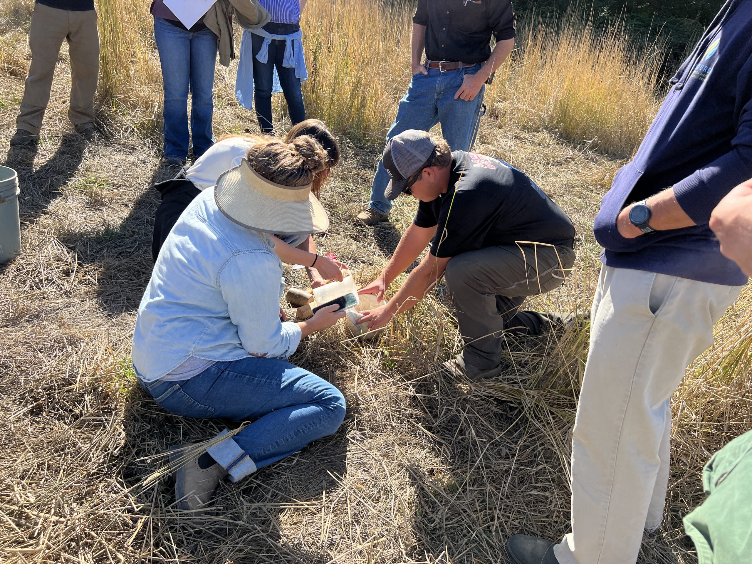
Attendees at a TKREF workshop learn how to do water infiltration tests.
08/25/2026
By: Kevin and Shae Lynn Watt, Bookcliff Consulting
For more than a decade, TomKat Ranch has monitored its landscapes and documented its grazing decisions as part of an effort to practice sensitive and adaptive stewardship. Alongside detailed ranch records, the team and its partners have tracked soil health, vegetation, birds, streamflow, and water infiltration. This work has supported research and education while also helping the team understand how the ranch responds to management over time. It has also raised a very practical question: How can all this information help land stewards make practical decisions?
This question helped inspire the creation of the California Regenerative Grazing Data Collaborative, a collection of California regenerative ranches and conservation non-profits interested in improving their understanding of the effectiveness of their grazing management (the Collaborative). In our 2025 wrap-up, we described a shared gap: participating ranches had accumulated valuable ecological and operational data, but the data wasn’t detailed enough to inform nuanced grazing management choices.
The Collaborative’s work in the first half of 2026 therefore focused on what it might take to close that gap to focus on a human-centered, decision-oriented approach to data – beginning not with everything that could be measured but with clear objectives around what people want to learn and do. This inquiry is leading the group to consider how monitoring programs are designed, experiment with new analytical technologies, and explore increasing focus on working lands and water dynamics.
Roadmap to Rangeland Monitoring
This June, the Collaborative learned from Dr. Kris Hulvey of Working Lands Conservation, lead author of Roadmap to Rangeland Monitoring: How Do We Produce Actionable Data on U.S. Public Lands? The paper draws on established monitoring protocols, interviews with rangeland experts, and collaborative case studies from across the West. Its central argument is that collecting trustworthy data is only the first step; developing insights from the data and making it useful is the harder challenge.
The Roadmap emerged from the Western Rangelands Data Initiative (WRDI), a Meridian Institute project that brought together ranchers, agencies, researchers, and conservationists from across the West. When Meridian ceased operations in 2025, several promising projects were left unfinished. TomKat Ranch Educational Foundation advocated for an intentional completion phase and agreed to serve as fiscal sponsor with support from Conscience Bay Research and the Mighty Arrow Family Foundation. Working with former WRDI staff and advisory group members, TKREF helped the re-convened WRDI publish the Roadmap, reconnect the network, and identify work that can be carried forward by partners.
Actionable Data
Monitoring can serve many purposes, from documenting regulatory compliance to establishing baselines for tracking long-term trends. Monitoring intended to support adaptive management, however, must do more. Ideally, it can help us connect a particular management action (e.g., timing, location, density, and duration of grazing) to an ecological or operational outcome at a scale where we can act or respond.
Hulvey and co-author Megan Nasto argue that monitoring becomes actionable when the people who design it clarify who will use the information, what decision the data is meant to inform, and what resources are available. This idea of “starting with the objective” is not new in the monitoring world, however, producers can find it difficult to articulate their data needs in terms that fit into traditional monitoring frameworks. The Roadmap emphasizes the value of “trigger points”: agreed-upon conditions that prompt a discussion or a change in management. For example, a monitoring team might decide that a certain increase in bare ground should trigger a conversation about grazing timing, recovery periods, erosion control, and necessary management responses. Establishing that expectation helps create a cycle where information informs actions.
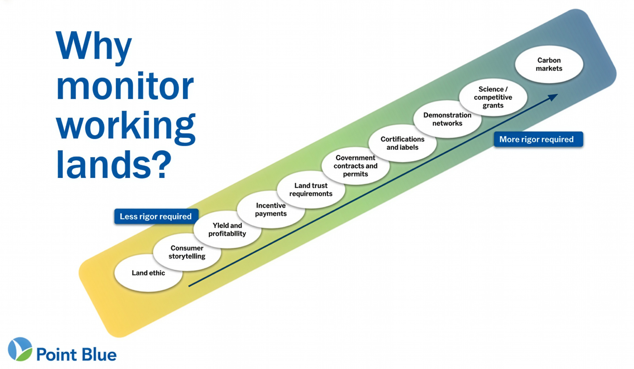
Point Blue Conservation Science uses this great graphic to illustrate how different objectives require different amounts of monitoring rigor.
This Roadmap framework resonated with the California Grazing Data Collaborative as we know that the usefulness of any metric depends on the landscape, the management question, and the people who can act on the findings. Even a technically rigorous dataset can miss distinctions that matter to a ranch manager, including variations in slope, soils, weather, animal behavior, or the timing of a particular rainstorm. Conversely, a relatively simple measurement can be highly valuable when repeated consistently, interpreted locally, and linked to a management decision.
People and Data
The Roadmap also highlights the social dimensions of monitoring. Rangelands are not only ecological systems, they are places where livelihoods, public responsibilities, cultural values, regulatory requirements, and community priorities overlap. Effective monitoring therefore requires more than protocols and technicians. It needs people who know the land, understand the practical realities of implementing change, and have the authority and/or resources to act on what is learned.
The paper’s case studies illustrate the value of bringing these roles together and bringing the principles of the paper into action. In Utah’s Three Creeks Grazing Project, ranchers, scientists, and state and federal managers examined how grazing duration and seasonal timing affected water quality, forage, riparian conditions, soil health, and sage-grouse habitat. Because the partnership included not only the people who collected the data, but also the people who manage the livestock, fund the improvements, and authorize the management changes, the findings documented conditions and informed action.
For our California-based Grazing Data Collaborative, this paper reinforced our foundational belief that testing regenerative monitoring systems needs to bring ranchers, researchers, analysts, conservation organizations, and technical partners into the same conversation. A diversity of perspectives is key to surfacing all the questions that matter and analyses that can inform real decisions and results on the ground.
Testing New Tools
Building from those lessons learned, several members of the Collaborative have begun testing proprietary artificial intelligence (AI) tools with their data in the hopes that new tools can help land managers interpret complex datasets and uncover fresh value in historical records. Ranch data is often fragmented across spreadsheets, maps, weather stations, grazing records, and monitoring reports, making it difficult to see relationships across years, places, and management decisions.
As we explore the potential of AI to support regenerative agriculture, we also need to take seriously its environmental and social costs. AI systems rely on data centers that can consume significant amounts of electricity and water, as well as hardware dependent on energy- and mineral-intensive supply chains. They also raise important questions about privacy, consent, ownership, and control when farm and ranch data are shared with proprietary platforms. Organizations working in and around regenerative and agroecological agriculture including OpenTEAM, IPES-Food, and ETC Group have emphasized the importance of farmer data rights, transparency, technological sovereignty, and ensuring that digital tools strengthen rather than diminish the agency of land stewards. OpenTEAM’s work on an Agriculturalists’ Bill of Data Rights is particularly relevant, emphasizing principles such as informed consent, privacy, portability, and the ability of producers to benefit from the data they generate.
This is a fast-moving field, and our hope is to contribute a regenerative perspective to its development and use. That means asking not only whether AI can produce useful analysis, but also whether the way we use it protects the people and landscapes from which the underlying knowledge and data originate. AI-assisted analysis may help identify patterns, anomalies, or possible relationships that would be difficult to detect through conventional review. It may also help teams compare management histories with ecological observations and decide where closer analysis is warranted.
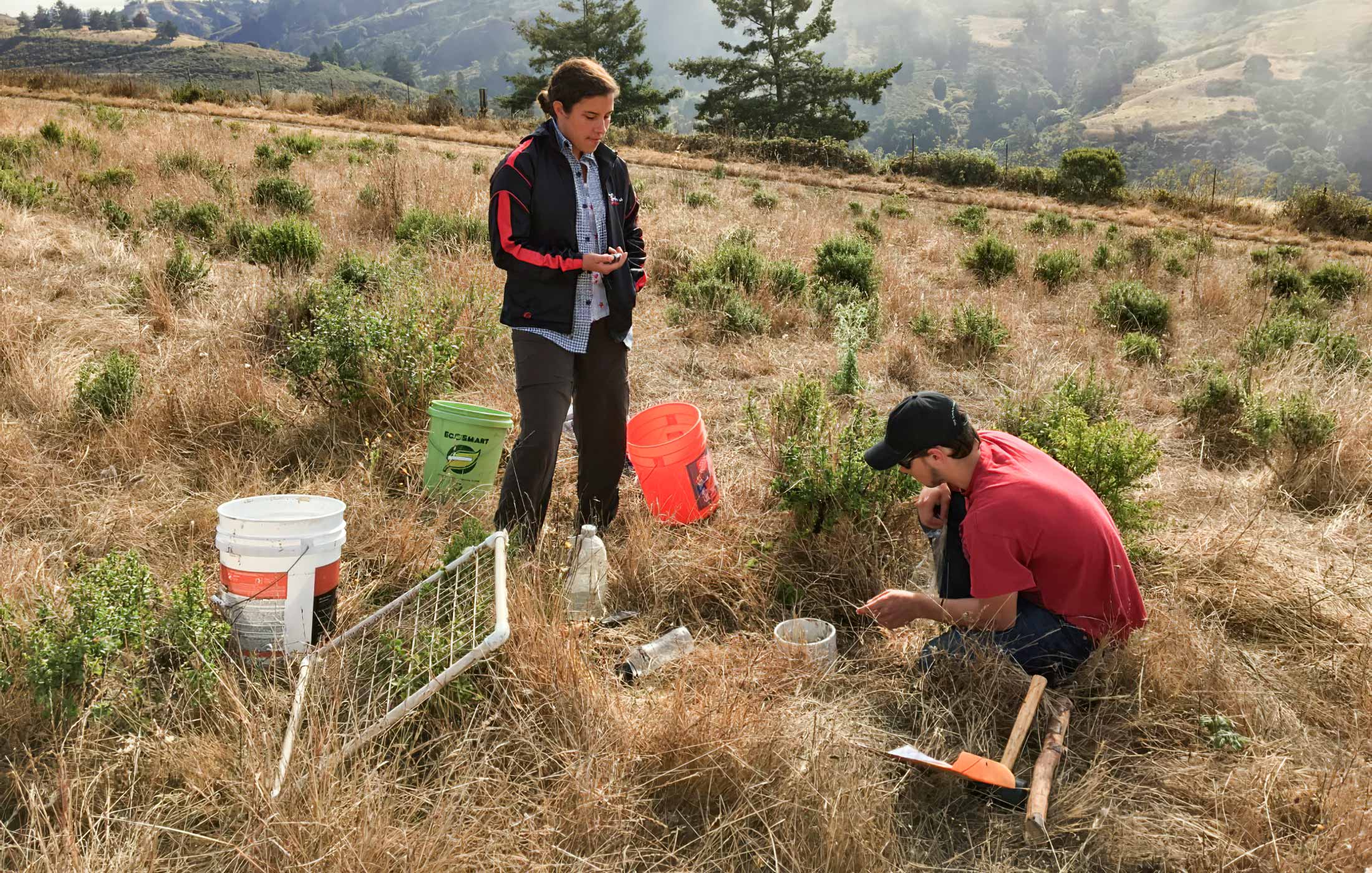
Interns at TomKat Ranch collect soil and vegetation data.
In our view, these tools are not replacements for ecological knowledge or real-world ranch experience. A statistical relationship is not necessarily causal, and an algorithm cannot decide what matters most to a ranch family and its community.
The Collaborative is therefore approaching AI as a supporting tool, with curiosity about its potential and appropriate caution about its limits. Interpretation and judgment must remain in human hands. Our goal is to explore whether AI can be used in ways that reduce rather than externalize environmental costs, protect the privacy and agency of land stewards, and ensure that the value created from agricultural data ultimately supports better stewardship and more resilient agricultural communities.
Water Rising to the Surface
As the group considers which information is most useful for management, water has increasingly emerged as a focal point. The Three Creeks Grazing Project, Point Blue Conservation Science’s Rangeland Monitoring Network, and many examples have shown that water connects many of the outcomes that regenerative land managers care about, including soil health, plant growth, biodiversity, forage production, economic resilience, and even rain. A functioning landscape can slow runoff, protect soil from erosion, allow more rain to infiltrate, and retain moisture for plants. These processes influence drought resilience, flood risk, habitat, water quality, and ranch operations.
Water is also immediate. A producer can observe a spring drying earlier, a pasture remaining green longer, a well drawing down, or a culvert flowing after a storm. Those observations do not prove why a change occurred, but they create understandable points of entry for monitoring and management questions.
TomKat Ranch’s three-part Water Cycle series (that appeared in our newsletter earlier this year) has explored these relationships in greater depth. Part One introduced the role functioning ecosystems may play in retaining and recycling moisture. Part Two considered how management choices affect infiltration and water retention, while Part Three explored how society might better recognize the value healthy ecosystems provide to both the small and large water cycles.
The Grazing Data Collaborative is now grounding a larger vision for water in local questions. Members have compared approaches to monitoring rainfall, soil moisture, evapotranspiration, groundwater, streamflow, runoff, and water quality. They have also been candid about the challenges. California’s variable weather makes year-to-year comparisons difficult. Equipment can be costly or unreliable, and attributing a change in streamflow or soil moisture to one particular management practice requires care.
Our emerging water vision is thinking across watersheds and how, when, and why different practices might help improve water cycle function within and beyond a landscape. This includes adaptive grazing, compost and other soil amendments, riparian planting, wetland and floodplain reconnection, road and runoff management, and low-tech process-based restoration where appropriate. No single practice will fit every landscape. The more useful questions are which combination of approaches can improve hydrologic function in a particular place and what evidence would allow managers to know whether those approaches are working.
What Comes Next
The California Regenerative Grazing Data Collaborative began by comparing spreadsheets, but its work has grown into a broader exploration of how knowledge is created, interpreted, and used. In the months ahead, members will continue testing analytical tools, revisiting long-term datasets with clearer questions, continuing to test and improve tools for collecting interoperable management data, and exploring water-related indicators that may better support regenerative stewardship.
No single metric will resolve every challenge. Rangelands are too varied, and management decisions too dependent on context. A clearer direction is nevertheless emerging: begin with the decision, collect information at the scale where action is possible, and keep the people who know and manage the land at the center of the process.
If you are interested in learning more, there are other efforts across the country that are exploring many of these same questions and topics. Here is a short list of some of the folks we are following: