In light of this particularly wet and cold winter, Part 2 of our Appreciation for Water series explores the connection between healthy soils, soil structure and texture, and water infiltration
Effective Rainfall: Putting All that Wonderful Rain to Good Use

This location was a deep erosion gully in 2018. We filled it with woody debris intentionally, creating filter traps in the bottom to capture sediment, raising the streambed, supporting vegetation growth, and reducing erosion as the water is spread and infiltrated rather than channeled. Today, this area is significantly more stable.
03/20/2023
By: Mark Biaggi and Megan Shahan

 In light of this particularly wet and cold winter, Part 2 of our Appreciation for Water series explores the connection between healthy soils, soil structure and texture, and water infiltration, with insights from 2022 data collection on TomKat Ranch. We wrap up with a simple assessment to help land managers determine how well rain is being absorbed into the soil, and some general considerations for creating the conditions for effective rainfall throughout the year.
We open with comments from TomKat Ranch Manager, Mark Biaggi, on managing land to be resilient in the face of prolonged drought and short periods of intense rain:
When it comes to land management, preparation for both drought and flood are the same. Drought-prone regions of the world need to be on guard for the next rain event (as we just experienced in California) and manage the land to support the infiltration of rainfall when it arrives. Management and land use decisions can create the conditions for what’s known as effective rainfall, measured as the percentage of rain absorbed and infiltrated into the soil. Creating these conditions moves us further along the spectrum of resilience, and restores local water cycles.
Lack of rain is a problem, but so is too much rain. All soils have a saturation point, and we have no short-term influence over the timing or volume of rain. We do, however, have an influence on our land management decisions, be they beneficial or harmful. Can we create the conditions so that when the rains come, it will be greeted by the open arms of healthy soils ready to infiltrate, store, and utilize it? Or, as a consequence of poor land management, will we lay the groundwork for a landscape inhospitable to its arrival?
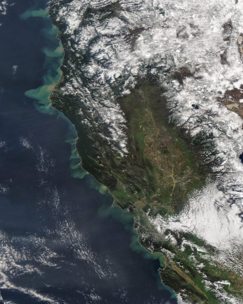
“Incredible satellite image from space showing all the sediment pouring out into the Pacific from gushing rivers across Northern California. Also notice the flooded Salinas Valley and muddied waters of the San Francisco Bay and rivers across the Sacramento Valley.” Thanks, Colin McCarthy (@US_Stormwatch) for sharing! Image from NASA’s Terra Satellite, accessed from EOSDIS Worldview.
Healthy Soils Support Effective Rainfall
Healthy soil with high percentages of soil organic matter is key to good water infiltration and water holding capacity. Microorganisms in the soil convert above and below ground organic material such as leaves, manure, or plant roots into soil organic matter via decomposition. The resulting organic matter provides a reservoir of water and nutrients for plants, which in turn support a soil environment teeming with life—the hallmark of healthy soils. The symbiotic relationships within the soil are a beautiful example of nature’s complex, diverse, interconnectedness and are the foundation of all life on earth.
In grasslands, farming, and forest systems, healthy soils are the foundation of productivity and increase resilience against drought, fire, and intense rainfall events. Creating the conditions to infiltrate (soak) water into the soil is critical. Water infiltration rates and the volume of water the soils can hold, referred to as water holding capacity, ultimately determine the land’s resilience to drought and flood.
When water holding capacity is poor (typically because of soil compaction and/or bare soil), plant communities, riparian habitat, and recharge rates of local aquifers are all affected. For example, the term plow pan refers to shallow compacted soil (typically at depths of 6-12″) created by repeated tilling, an almost impenetrable barrier inhibiting the movement of water and air, and limiting root growth. Fields with a plow pan can only effectively infiltrate rainfall until the soil above the plow pan is saturated, at which point sheet flow (runoff), a common source of erosion, occurs. Plow pan can result in reduced production of forage or crops and the associated water runoff can lead to the loss of valuable topsoil.
How we manage soil has a direct influence on the condition of our land and water. Agricultural practices such as chemical applications, repeated tilling or overgrazing can lead to compaction and bare ground, reducing the soil’s ability to absorb water. These practices have the ability to damage both soil structure and soil biology depending how they are applied. The differences can be stark, as is demonstrated in this rainfall simulation video from NRCS.
Every 1% increase in soil organic matter in the top 8” of soil is estimated to increase the soil’s water holding capacity roughly 10,000-25,000 gallons per acre. The estimated range of this relationship highlights two important realities: 1) increasing soil organic matter can significantly increase the soil’s ability to hold water, and 2) living systems, including soils, are highly complex and variable, as reflected in the variability in research outcomes, and thus require careful observation and adaptive management.
Effective Rainfall In Aggregate: Soil Texture and Water Holding Capacity
To add to this complexity, all soils are not created equal. Water holding capacity is a product of healthy soil with a high degree of porosity, a measure of voids in a given volume of soil. Soil particles—sand, silt, clay—group together and form aggregates, and the term soil structure refers to the various shapes in which they form. Pore space in the soil is created by soil organic matter holding soil aggregates apart, creating voids for water, air, and plant roots, and simultaneously stabilizing soil aggregates so they aren’t flushed away by water.

Soil type, or texture, is determined by the ratio of sand, silt, and clay (see Soil Texture Triangle) and has a high degree of influence on soil porosity. Ideally, soil is made of about 45% minerals (sand, clay, silt), 5% organic matter, 25% air, and 25% water. Loam soils, which have a mineral composition of roughly 20% clay, 40% silt, and 40% sand, have a well-balanced particle size and are potentially the most fertile and productive soils for agriculture or agroforestry.
Loam soils generally contain more nutrients, moisture, and humus than sandy soils, and have better drainage and infiltration of water and aeration than silt and clay-rich soils. Loam soils are stable and less prone to compaction than clay soils. If managed appropriately, they have a high water retention which supports a longer growing season. Clay soils, on the other hand, are prone to compaction and difficult to regenerate; therefore, clay soils must be managed carefully.
Nature is diverse. It is typical for numerous soil textures to be present on an area of land, especially in California. For example, soils at TomKat Ranch are classified most commonly as clay loam (depicted roughly in the center of the Soil Texture Triangle, above); however, clay, sandy clay loam, loam, and silty clay texture categories can also be found.
Land management and soil texture influence whether there is sufficient pore space (open space between soil particles) and a crumbly soil structure to allow water and oxygen to move freely and interact with microbes and plants. Healthy, porous soils are the basis for resiliency, water retention, and a thriving ecosystem of microorganisms and plants.
Creating the Conditions for Effective Rainfall
TomKat Ranch’s approach to regenerative land management is adaptive. Ecosystems are dynamic and stewardship decisions are made in the face of constantly changing conditions. Adaptive management is the process of inventorying resource concerns, taking action to address those concerns, monitoring the results of those actions, and refining future actions based on the outcomes. Adaptive management is how we care for our ecosystems in the face of ecological uncertainty.
Though the amount and timing of rainfall is outside of our control, good land management can lead to more effective rainfall via improved soil health that increases infiltration rates, holds more water, and ultimately replenishes springs and aquifers. We focus on managing to promote ideal conditions so that when it does rain, there is minimal or no runoff.
“TKR receives an average annual rainfall of 27 inches. In the past 6 years, annual rainfall has ranged from 14 inches to 44.5 inches (YTD and counting). If you think about rainfall as income, imagine I promise to pay you $27,000 per year on average. But some years I pay you half that and other years twice that. Generally I pay your salary over 6-7 months but some years I pay you in only a few months, leaving you to figure out how to plan and budget for the remaining 7-9 months of the year.
You never know in advance what I will pay you and there are often additional costs associated with any year of extremely high salary. That’s what it’s like being a farmer or rancher, and more so in today’s climate with the increased intensity and unpredictability of both rainfall and dry periods.”
-Mark Biaggi
How does a land manager know what to do? First and foremost, we must understand our Context. This includes developing a place-based understanding of soil type, soil organic matter, agricultural history (legacy tillage or chemical use), slope, predominant plant community—just to start.
TomKat Ranch partners with Point Blue Conservation Science (Point Blue) to develop a scientifically informed understanding of our context, which guides our management decisions. Below we share some insights from our 2022 data collection as they relate to groundwater recharge potential and water infiltration. These independent data sets inform preliminary recommendations for how to manage water during increasingly intense storms.
The Basin Characterization Model (BCM), depicted in the map below, predicts a number of water-related variables across California including groundwater recharge and climatic water deficit. The data on groundwater recharge potential at TomKat Ranch indicates the highest recharge potential is on the East side of the ranch (areas in green).

Using Rangeland Monitoring Network data collected at TomKat Ranch, Point Blue interpolated water infiltration across the ranch to better understand places of faster and slower infiltration (map below). Combined with the BCM, these data suggest that it could be strategic to prioritize practices that slow and spread water (e.g., beaver dam analogs, one-rock structures) on the East side of the ranch where infiltration rates and recharge potential are high. On the West side of the ranch, these data suggest that minimizing erosion is a priority.

Infiltration rates determined by standard water infiltration testing methods in accordance with the NRCS SQ-Soil Quality Test Kit Guide and the Point Blue Rangeland Monitoring Network.
Data like this informs our management actions, as does careful observation and relationship with the land. Some of this observation can be quite simple. Below is a visual assessment to determine if rainfall is being effectively infiltrated into the soil:
- Do the initial rains soak in or run off?
- Is water running off the land before the soil is fully saturated?
- Is there enough vegetative cover or litter to slow water and allow for infiltration?
- Are management decisions causing water to collect in areas and run off rather than spread and infiltrate (i.e. fences that lead to livestock trailing, roads that lack waterbars, or row cropping up and down slopes rather than along contours).
- How long do your streams (both seasonal and perennial) run clear or opaque during the rainy season?
- When storms arrive, do your stream levels rise rapidly and drop quickly post storm? Or do they rise slowly, steadily and then decrease over an extended period of time?
Whatever the condition of the land today, intentional management actions and adherence to the soil health principles can create the conditions for more effective rainfall, increasing resilience and productivity despite uncertain conditions. Below are four generally applicable approaches to managing water throughout the year, whether it is unseasonable wet or dry:
- Intentionally direct the flow of water. There is a great permaculture adage about water that says: “slow it, spread it, sink it.” When water is slowed and spread across the landscape, it has the opportunity to infiltrate into the soil. Conversely, when water is channeled, it gathers energy with the potential to create gullies that erode soil, degrade water quality, and endanger roads and infrastructure. Channeled water is commonly found at roofs, roadside ditches, culverts, channelized streams, paved roads and parking in rural and urban communities alike.To support infiltration and limit erosion, aim to slow it, sink it, spread it, and avoid gathering or channeling of water. New structures can be designed to slow and spread water from the outset. In areas where water is channeled, intentional management actions, tools, and structures can slow and spread the water back out on the land and/or reduce the energy with which the water is flowing. Some examples of possible tools and structures include:
- Energy dissipators such as large rocks/boulders and logs at culverts;
- Check dams, large woody debris structures, beavers or beaver dam analogs in channelized streams;
- Water bars, rolling dips, vented fords around roads; and
- Woody debris structures and sediment traps in erosion gullies. For readers in San Mateo County, our local Resource Conservation District has published a detailed gully erosion report.
- Restore riparian corridors. Vegetated riparian corridors help slow and infiltrate water. They also have a comparatively high water holding capacity, which can extend the growing season and positively influence the surrounding areas. Vegetation in riparian areas can be bolstered by well timed adaptive grazing (including possible grazing exclusions at certain times), planting riparian plants, and rehabilitating erosion gullies. Healthy riparian corridors also play an important role in increasing the fire resiliency of land by slowing or stopping a fire.
- Build off-season storage [Note: State or county permits may be required. Your local RCD can help.] Ponds can be an excellent tool for storing water from the rainy season to use during the dry season. Ponds can also be placed to capture surface sheetflow from fields, roofs, and roads, or be filled by pumping in excess flows from streams in the rainy season. Strategic pond placement can reduce erosion (if designed to capture sheetflow runoff) and decrease dry season reliance on streams and wells, allowing them to recharge. Areas of clay soil are excellent for building ponds.
- Create conditions that promote water infiltration. Mechanical and chemical disturbances can damage soil aggregation causing the soil structure to compact and/or collapse. In doing so, the capacity of soil to infiltrate, capture and hold water is reduced. To increase water infiltration, promote soil health through these soil health principles:
- Minimize soil disturbance: Consider how to offset/reduce the disturbance within your context of grazing, farming, gardening
- Maximize diversity: Above ground, a diversity of crops and livestock lead to a diversity of plants and microbes below ground
- Keep the soil covered: Limit bare and exposed soil
- Maintain living roots for as long as possible: Within your context as a farmer, orchardist, grazer, etc.
In closing, we have included two recent videos from TomKat Ranch Manager, Mark Biaggi, illustrating the positive impact of woody debris structures in riparian area restoration and conversely, the missed opportunity of channelized streams rapidly moving water off the landscape. Managing water is a dynamic process, and progress is made over time in many different forms. There is no one size fits all approach, and it starts with understanding your context, your particular resource concerns, and your goals. We are constantly learning—from each other, from this land—and are grateful to be on this journey with you all.
March 10, 2023. Stream conditions near Upper China pasture after 3.8 inches rain in 24 hours, 2.8 inches of which fell overnight. This location was a deep erosion gully and in 2018, we filled it with woody debris intentionally creating filter traps in the bottom to capture sediment. Today, there is 15-20 feet of wood (trees, limbs, etc.) acting as a sediment trap that has filled in over years, raising the streambed, supporting vegetation growth, and reducing erosion as the water is spread and infiltrated rather than channeled. Today, this area is significantly more stable.
March 10, 2023. Stream conditions near the old apple orchard. This stream is severely incised (or channelized) and water flows with significant energy through and off the land with little to no opportunity to disperse on the lower bank (as above). Such conditions can result in more water flowing downstream, leading to erosion and adding to the flood risk in town.